

The Atlantic hurricane season, which runs from 1 June to 30 November, has been unusually quiet this year.
So far, eight tropical storms have formed: Arthur, Bertha, Cristobal, Dolly, Edouard, Fay, Gonzalo and Hanna.
None of those reached hurricane strength, setting a satellite-era record for the latest formation of a season's first hurricane.
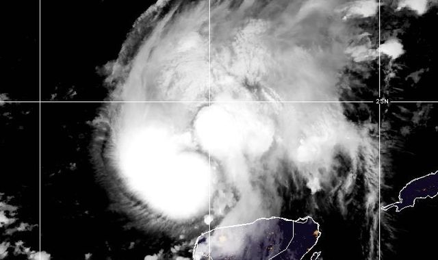
The ninth tropical storm, Isaias, has now strengthened, becoming the Atlantic's first hurricane this year.
The National Hurricane Centre expects Isaias to intensify over the Gulf's very warm waters into a high-end category two hurricane before reaching the US Gulf coast late on Friday or early on Saturday.
But it remains unclear how much the hurricane will be affected by strong wind shear - changes in wind speed and direction with height - near the coast.
Landfall is most likely in Mississippi, Alabama or the Florida Panhandle.
Warnings are in force, with a life-threatening storm surge of 5ft to 7ft (1.7-2.1m) the main concern for the low-lying coastal regions.
Heavy rain, as much as six inches, and damaging winds, are also expected to affect the area.
If it continues to strengthen, it could become a category three storm, defined as one with wind speeds of 111-129mph (179-208kmh), according to the Saffir-Simpson Hurricane Wind Scale.
Should this happen, there could be extensive structural damage to small buildings and serious coastal flooding in low-lying areas, potentially necessitating evacuations.
Florida Governor Ron DeSantis declared a state of emergency for 25 Florida counties ahead of Hurricane Isaias' arrival.
After moving inland, Isaias will weaken rapidly, although heavy rain will affect a broad area of the southeastern US this weekend.
No other storms are forecast in the Atlantic Basin within the next seven days.
Read more on Sky News:
What happens if the UK runs out of gas?
British consulate becomes UK Mission
UK sees second-highest wildfires total
The Atlantic was forecast to have a quieter hurricane season this year because of the 'historic' El Nino event in the Pacific.
In the Atlantic, El Nino increases wind shear, which can disrupt thunderstorms before they become tropical storms or hurricanes.
Dry, dusty air across the region is further suppressing storm formation.
By contrast, El Nino has likely increased hurricane activity in the eastern Pacific.
The basin has recorded 19 tropical storms, including nine hurricanes, seven of which reached major hurricane strength at category three or above.

(c) Sky News 2026: Isaias heading for US mainland - the first Atlantic hurricane this year

 Andrew Mountbatten-Windsor and Thames Valley Police agreed warrants to raid two properties were unlawful
 Two Latvian nationals arrested on suspicion of trespassing at RAF base
 Royal Navy serviceman accused of plotting to leak intelligence to Russia appears in court
 Venezuela's Nicolas Maduro and wife facing torture charges
 Edinburgh teacher unleashed 'traumatic' attack on Nicky Campbell when he was a schoolboy, court hears
 Lithuania PM confident of 'huge' NATO response if Russia attacks
 British consulate in Jerusalem to become 'UK Mission' as diplomats leave
 Sisters pulled from sea near Brighton took own lives, coroner rules