


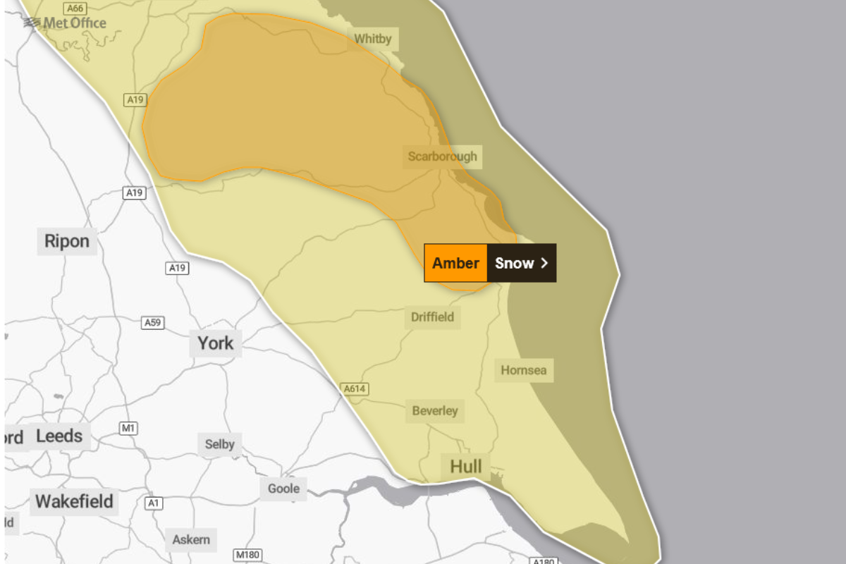
Residents along the Yorkshire coast and surrounding areas are being urged to prepare for significant wintry weather as the Met Office issues an Amber warning for snow on Thursday.
The warning applies to areas including North Yorkshire and the East Riding of Yorkshire.
A yellow warning for snow and ice runs from 00:00 (UTC) on Wednesday until 23:59 (UTC) on Thursday. The Met Office details state that wintry showers feeding inland from the North Sea through Wednesday and Thursday may lead to disruption.
A more sever Amber warning for snow has now also been issued from 03:00 on Thursday to 21:00 on Thursday. The MET Office says:
"Frequent wintry showers, leading to significant snow accumulations, are likely to cause disruption on Thursday"
"Frequent wintry showers will feed inland from the North Sea, giving significant snow accumulations over the North York Moors and parts of the Yorkshire Wolds.
By the end of Thursday, as much as 15-25 cm may have accumulated on hills above 100m elevation, which is likely to cause substantial disruption.
Gusty winds, giving occasional blizzard conditions, and perhaps a few lightning strikes, may accompany some of the showers, posing as additional hazards."
Netweather Forecaster Jo Farrow highlighted the nature of the weather system affecting the region, driven by northerly winds off the sea.
"Along the North Sea coast this happens sometimes when you've got the flow off the sea, northerly wind, and it's going to keep on bringing these snow showers to that Yorkshire coast.
You've got ice in that warning as well. Some areas seeing really heavy snow showers.
That's Wednesday morning, all the way through Wednesday, overnight, and then all the way through Thursday.
So, that's a lot of snow showers coming into that coast, and that's why the Met Office have got that yellow warning for snow and ice."
The Met Office anticipates that while there will be regional variation, with some places seeing little or no lying snow, where showers are most frequent, accumulations of 2-5 cm are possible. However, substantial accumulations are anticipated on higher ground. The North York Moors, and perhaps parts of the Yorkshire Wolds, could potentially receive 15-25 cm of snow by Thursday, which may lead to significant disruption.
Forecaster Jo Farrow noted the difficulty in predicting specific local amounts due to the shower nature of the event, particularly contrasting potential falls at lower and higher elevations.
"Even to lower levels that there's talk that there could be just a few centimetres if you're caught in one of those lines of those showers.
But on the higher ground, um there's mention of perhaps 10 to 15 cm of snow by the time we get to the end of Thursday. So that's quite a lot of snow.
There will be some areas that are just where these showers are coming and coming off the sea and they'll get a lot of snow and then it could be 2 miles down the road you don't get as much and then feel, oh, why did we have a yellow warning? So yeah. That's tricky to try and convey for us."
Additional hazards accompanying the snow showers include gusty winds, and possibly a few lightning strikes. Ice is also a risk, particularly where snow persists and partially thaws, only to then refreeze overnight.
Expected Disruption and Safety Advice
The Yellow warning signifies a risk of potential impacts that could disrupt residents' plans, according to the Met Office.
The Met Office warns that possible travel delays on roads could occur, potentially stranding some vehicles and passengers. Furthermore, bus and train services may be delayed or cancelled, with road closures and longer journey times possible. The sources also highlight that untreated pavements and cycle paths might become impassable, increasing the chance of injuries from slips and falls on icy surfaces.
The severe weather also carries the risk of power cuts, which may subsequently affect other services, such as mobile phone coverage. There is also a risk that some rural communities could become cut off.
In addition to the main snow and ice warning, a separate Yellow warning for ice covers the region between 00:00 (UTC) and 11:00 (UTC) on Wednesday. This specific warning details that rain and hill snow, followed by clearing skies and falling temperatures, will lead to the risk of icy patches on untreated surfaces. Significant snow accumulations during this period are largely restricted to communities and transport routes above about 300m elevation.
The Met Office advises the public to take steps to ensure safety when it is icy, suggesting planning to leave the house at least five minutes earlier than normal to reduce the risk of accidents, slips, and falls. Those making journeys on foot or cycling are encouraged to stick to pavements and main roads that are more likely to have been treated.
When driving, people should check road conditions, and bus and train timetables, amending travel plans if necessary. The Met Office also recommends staying up to date with the weather forecast, as warnings can change quickly. Individuals are encouraged to prepare in advance for the risk of power cuts, considering gathering items such as torches, batteries, and mobile phone power packs.

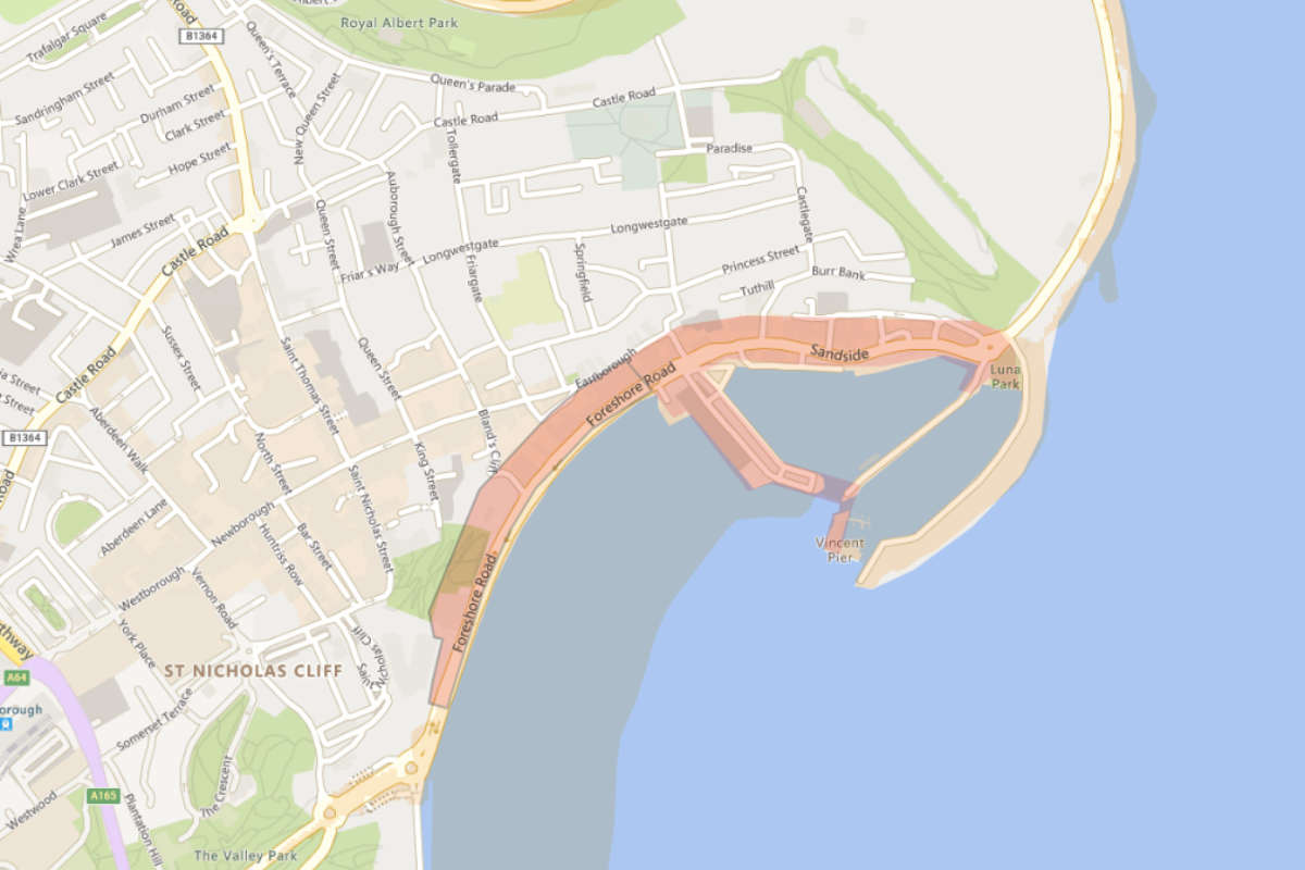 Flood Warnings Issued For Scarborough's Sandside & Foreshore Road
 East Riding Council Facing "Tough Decisions" as New Operating Model Signals Looming Redundancies
 Location for Scarborough's 400th Anniversary Sculpture Confirmed
 New Chief Exec for Yorkshire Air Ambulance
 Scarborough and Whitby MP Presses for Burniston Fracking Decision to be Delayed
 Pickering and Filey MP Criticises Government for ‘Unfair’ Rural Funding Settlement
 East Riding to Introduce Weekly Food Waste Collections Amid Long-Term Funding Fears
 Eastfield Boxing Club Film to Get Scarborough Premiere
 Scarborough Athletic Stunned By Minnows in Senior Cup
 Whitby Town Again Hit By Second Half Slaughter
 Scarborough Café and Flat Plans Opposed by Town Councillors
 Bridlington Town Beaten Again Despite Improved Showing


Comments
Add a comment