


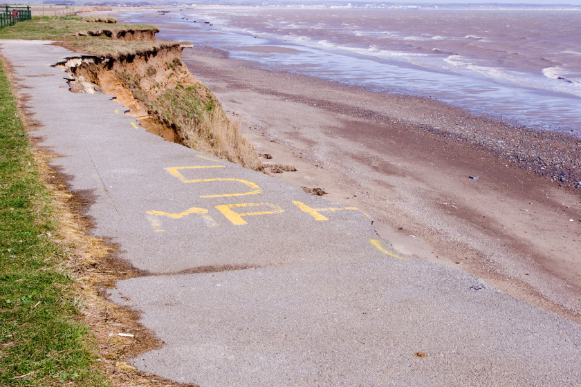
Following updated coastal erosion rate projections from the Environment Agency, the East Riding of Yorkshire Council is requesting an urgent meeting with the Minister to discuss support for affected communities
Council leader, Councillor Anne Handley, put forward the motion in light of the "devastating news" delivered by the Environment Agency regarding updated prospective coastal erosion rates, which will have an immediate impact on the future plans of many residents.
The Environment Agency's new National Coastal Erosion Risk Map (NCERM) offers an updated view of coastal erosion risk in England. The NCERM is based on coastal monitoring data from the National Network of Regional Coastal Monitoring Programmes and accounts for UKCP18 climate projections, including allowances for sea level rise. The projections in the NCERM extend to mid-century (2055) and the end of the century (2105) and reflects the latest coastal management approaches outlined in Shoreline Management Plans (SMPs).
The new NCERM shows that approximately 3,500 properties around the UK are at risk of coastal erosion by 2055, and this number is expected to rise to about 10,100 properties by 2105. These figures assume that funding and implementation of all actions in the SMPs are delivered. However, if SMPs are not delivered, the number of properties at risk could increase significantly, potentially reaching 32,800 by 2055. Even with SMPs in place, approximately 19,700 properties could be at risk by the end of the century, accounting for climate change. Without SMPs, this figure could be five times greater.
Yorkshire and The Humber, the South West, and the East of England have the highest numbers of properties at risk. East Riding of Yorkshire, along with North Norfolk and Cornwall, contains two-thirds of all residential properties in areas at risk of coastal erosion in England. These local authorities are part of the £36 million Coastal Transition Accelerator Programme (CTAP), which explores how coastal communities and businesses can adapt to the effects of erosion and climate change
Councillor Handley says the impact on the East Riding will be significant.
The Environment Agency says there are several reasons for the changes in risk assessment:
- Improved coastal analysis techniques are being used to assess coastal erosion at approximately 8,000 locations along the coast.
- The Environment Agency is using an additional 10 years of coastal monitoring data from the National Network of Regional Coastal Monitoring Programmes.
- There is updated information on the condition of coastal defences, including improved methods for estimating the chances and impacts of defence failure.
- Better information is available on a wider range of properties at erosion risk in coastal locations, including caravans, tourist, leisure, and business properties.
A meeting of full council backed Councillor Handley's motion, the authority will now seek a meeting with the government minister to discuss what support will be considered and given to affected communities moving forward.

 Train Services Suspended As Large Crop Fire Blocks Railway Line Near Filey
 Human Artists To Be Prioritised For Future Commissions Following Scarborough AI Backlash
 Yorkshire Fire Services Unite To Prevent Devastating Summer Wildfires
 Scarborough And Bridlington Hospitals Face 'Unprecedented' Financial Challenge
 £2.5 Million Upgrade Plan for Scarborough Cremation Services
 Extensive Sea Search Prompted By Reports Of Struggling Paddleboarder Near Port Mulgrave
 'Park And Ride Service Is Putting Pedestrians In Danger', Says Whitby Councillor
 Scarborough Shop Owner Ordered to Pay Over £3,300 for Illegal Tobacco and Vapes
 Major Restoration Programme Begins On Fire-Ravaged Fylingdales Moor
 Scarborough Athletic Seek Bumper Crowd For Tigers Test
 Hidden Batteries Spark Dangerous Fires Inside Yorkshire Bin Wagons
 North Yorkshire Blaze Risk: Disposable Barbecues Face Potential Ban


Comments
Add a comment