


North Yorkshire Council have updated the list of closed roads which still includes the A171 between Scarborough & Whitby and the B1416. Some moorland paths are affected too.
Emergency Services have added a map of road closures and an updated list below:
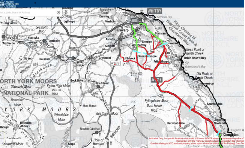
They confirmed the current list of closed roads:
• A171 Robin Hoods Bay turn to Cloughton - (C219 Sledgates to C77 Newlands Road)
• A171 Summerfield Lane to Fern Farm, Hawsker
• B1416 Sneatonthorpe (Dean Hall Brow to A171)
• C78 Public House to Ruskin Lodge, Harwood Dale
• C206 Gowland Lane, Cloughton
• C224 Moorgate, Littlebeck (A169 to U2335 Lousy Hill Lane)
• U2335 Lousy Hill Lane, Littlebeck
• U2346 Raikes Lane, Sneatonthorpe
• U2349 Road from High Normanby to Whitby to Scarborough Road, Hign Normanby
• C78 Gainforth Wath Road, Staintondale
• C85 Bridge Home Lane to Evan Howe Pond, Fylingthorpe
• C219 Sled Gates to Latter Gate Hills, Fylingthorpe
• U2413 Stoupe Brow to Stoup Bank Farm, Fylingdales Moor, Junction Cinder Track
• C85 Bridge Home Lane to Low Farm, Fylingthorpe, Junction Cinder Track
• C70 Helworth Road, Harwood Dale (Junction A171 Helworth Road to Gowland Lane)
• C225 Stainsacre Lane, Stainsacre (Junction A171 Stainsacre Lane, Whitby)
• C225 Sneanton Thorpe Lane, Sneatonthorpe (Junction U2346 Raikes Lane, Sneatonthorpe)
These closures are in place due to heavy smoke.
On Thursday, the North Yorkshire Moors Authority added the following:
'Due to the spread of the moorland wildfire in and around Fylingdales Moor, the Coast to Coast walk has been closed temporarily from Grosmont to Hawsker.
'Please avoid walking or cycling in the vicinity of the affected area.
'Coast to Coast walkers are advised to pick up the Esk Valley Walk at Grosmont, following the leaping salmon waymarkers to Whitby. At Whitby, follow the Cleveland Way to Robin Hood's Bay - though please note that smoke may be affecting this section.'

 Scarborough Athletic Stunned By Minnows in Senior Cup
 Pickering and Filey MP Criticises Government for ‘Unfair’ Rural Funding Settlement
 East Riding to Introduce Weekly Food Waste Collections Amid Long-Term Funding Fears
 Whitby Town Again Hit By Second Half Slaughter
 Eastfield Boxing Club Film to Get Scarborough Premiere
 Scarborough Café and Flat Plans Opposed by Town Councillors
 Bridlington Town Beaten Again Despite Improved Showing
 Scarborough Chip Shop's Alcohol Bid Approved Despite Concerns
 East Riding Leaders Sound Alarm Over Government's 'Fairer Funding' Review
 Precept Increase Proposed for Whitby Residents in Draft Budget
 North York Moors Park Authority Agrees Move to New £4m HQ


Comments
Add a comment